Why NationalMap? 5 Reasons Your Business Needs New Zealand's Most Trusted Mapping Solution
by Steve Critchlow, Group Managing Director, on 05-May-2016 07:30:00
When it comes to “taking sides”, we’re predominately Team Elephant. In fact, we pioneered said elephant in New Zealand many moons (25 years to be precise) ago. And while we have the utmost respect for all those shiny, colourful free map data offerings, there’s a reason why our elephant – or, more aptly named, NationalMap – has stood the test of time with organisations big and small.
The success of a business can come down to one thing: Quality Mapping Data
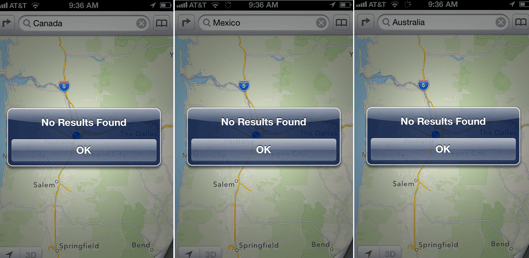
This isn't the kind of glitch you need when your business success depends on mapping data.
Maybe you’re a company that delivers to tens, hundreds or thousands of customers each day. Perhaps you’ve got staff on the road and getting from A to B quickly and safely means saving time and money and minimising risk. It could be that you need to know the specifics of where rural meets urban and what lies between. Or maybe your reliance on a trusted mapping solution is what helps you understand the city and communities you’re working in.
Your business needs may depend on distance, statistics, location, safety, cost-effectiveness, or all of the above. But no matter what those needs are, they’re only going to be met 100% with mapping data that provides a precise and comprehensive solution. We’re talking about a solution that includes everything from a visually detailed and accurate display, to a platform that can be integrated, scaled, and deployed in a way that’s unique to your business.
Why choose NationalMap?
It’s feature-rich: see New Zealand in all its detailed aerial glory
When any part of your business success depends on map data to run efficiently, you want that data to not only be accurate, but as detailed as possible.
What good is a map to your organisation if it’s incorrectly showing (or worse, entirely missing) vital information? Perhaps roundabouts have been omitted, directions that are meant to lead you to a certain place end up leading you straight into the wilderness or a lake (it’s happened!), or alternate road names are absent… we’ve all heard the stories. And yes, it’s likely these issues don’t seem too problematic on paper, but in real life, when a company’s time and money is involved? Well, these “quirks”, if you will, have the potential to really throw a spanner in the works.
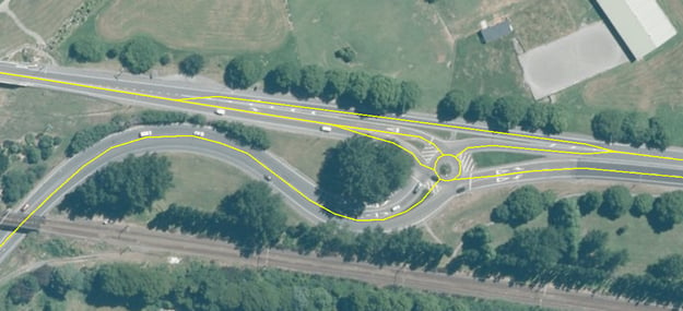
NationalMap is brimming with positional accuracy, representing an outlay that is true.
With NationalMap, a plethora of data is available – everything your business needs (and everything you didn’t know you needed) is at your fingertips. It’s incredibly feature-rich, using high resolution and up to date aerial photography to accurately represent a detailed outlay of everything from roundabouts and junctions, to road layout and physical location. Also included are alternate and alias road names (which there are plenty of throughout New Zealand), as well as highly detailed data showing transport terminals, fords, flora and fauna, and parks and reserves – so you’ll have an in depth and advanced overview of where everything is.
Near real-time data: an open door to information that is constantly updated
The incredible data team tasked with keeping NationalMap consistently up to date have one key thing in common: they know New Zealand. They understand it’s conditions and it’s fast-changing pace. They’re subject matter experts who literally pour over data each day to keep the product current.
With three different cycles (monthly, quarterly, and biannually) NationalMap’s data is always up to date. From cadastral data and legal boundary updates each month, to full reviews, upgrades and additional data for cycleways, education, flora and fauna, new roads, one ways, roundabouts, and more every six months – you can rest assured that the data you’re relying on is accurate, current, and reliable.
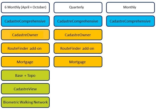
NationalMap Release Diagram
Consistency is key: we focus on New Zealand from top to bottom and every single bit in between
Critchlow is ISO 9001 accredited, which means we apply those processes when updating our data. The outcome? We’re consistent across New Zealand. And because NationalMap is focused only on New Zealand, we’re not spreading our attention, effort, or knowledge thin across any other countries – all our brain power goes into making NationalMap the most complete and accurate mapping system in the country.
You’ll also find that we’re consistent across both large and small communities, urban and rural. Where free mapping systems are often detailed in areas where there is a bigger user community, they can fall short in more remote areas where the population is smaller or more spread out. So, with NationalMap, you’ll be safe in the knowledge that whether your business focuses on the whole of New Zealand, a single urban area, or a small territorial authority, the data you’re privy to is consistently correct and never lacking.
It’s all about the add-ons: NationalMap has the potential to grow and grow…
Not only does NationalMap offer an in depth base dataset, there’s also a variety of specialist add-on modules that offer even more comprehensive display and analysis – from elevation or mortgage add-ons, through to routing and cadastre add-ons. So no matter what industry you’re in or how you use NationalMap, there’s bound to be a module that will allow you to further utilise the platform to full potential.
You can take a closer look at the individual modules and what ones are right for your business here.
New Zealand’s trusted mapping system, tailored specifically to your business needs
When you’re looking at investing in any sort of platform – be it accounting, client management, project management, or in this case, mapping and location data – the key thing most customers want is exclusivity; something that offers relevant and comprehensive information unique to their business’ needs.
NationalMap offers exactly that.
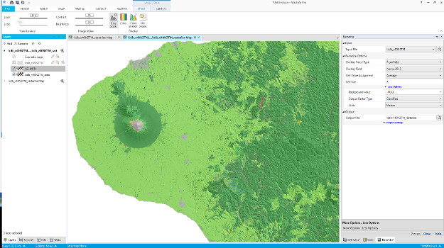
NationalMap is compatible with many different programs, including MapInfo
It is completely scalable, ready to fit in with your requirements and price bracket. Whether you need in depth information for the whole of New Zealand or your focus is solely on a town or territorial authority, our NationalMap offering will be tailored to suit you.
The platform is also directly compatible with a number of different programs (such as Esri, MapInfo, and Integraph, to name a few) which means no time wasted on integration and configuration from your organisation’s end, and the added promise of seamless overlays and common datasets.
Mapping solutions for business don’t get much better than this
In this day and age, it’s fantastic (and we’re lucky) to have access to free and easy to use mapping solutions. When I want to get from A to B around the city, I love being able to pull up Google Maps with tap of a finger and there’s my route, complete with approximate time and a rolling directional commentary should I want one.
But unfortunately, more often than not, these basic and free mapping platforms just don’t cut it when it comes to businesses who rely on in depth, concise, up to date, and intuitive data to run their company successfully. And what NationalMap offers is all of this – rolled up into a package that includes valuable modular add-ons and is tailored to suit your business’ unique needs and price bracket.
So what are you waiting for? If you want to know more about how NationalMap can help your business save time and money and increase efficiency, get in touch now.




.png)